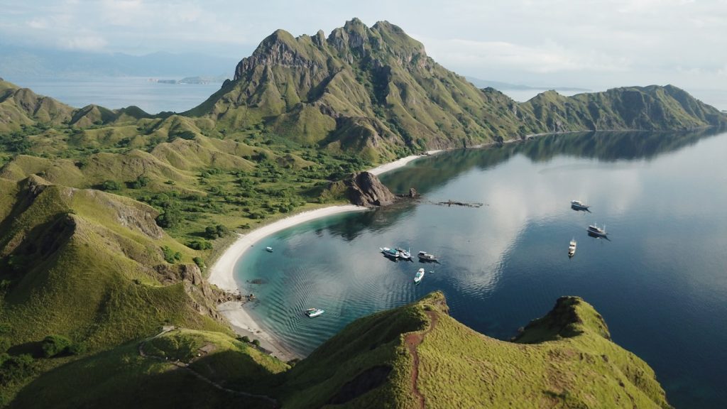
Parapuar is the integrated tourism development area on the forested hillside directly above Labuan Bajo town, managed by BPOLBF — Badan Pelaksana Otorita Labuan Bajo Flores — under Indonesia’s Ministry of Tourism. In Manggarai, the language of the people of West Flores, the name is a compound: para means gate or door, and puar means forest. Parapuar, then, is literally the gateway to the forest — a phrase that shapes, and burdens, everything the zone tries to be. It sits inside the Nggorang Bowosie forest in Kecamatan Komodo, Kabupaten Manggarai Barat, NTT, roughly five minutes from Komodo International Airport and seven minutes from the Labuan Bajo marina waterfront (distances in kilometres are unverified; the minute-estimates come from a Tempo English report, 2024).
This page tracks what Parapuar actually is — its legal basis, its four zones, the land figures that often circulate with errors, the infrastructure that exists today versus what is planned, and the Bowosie forest history that any honest account of the zone must address.
The Legal Foundation: Perpres 32/2018 and BPOLBF’s Dual Mandate
Parapuar exists because of Presidential Regulation No. 32 of 2018 (Perpres 32/2018 tentang Badan Otorita Pengelola Kawasan Pariwisata Labuan Bajo Flores), signed 5 April 2018 and promulgated 8 April 2018. The regulation created BPOLBF with two distinct mandates running in parallel.
The first is coordinative: BPOLBF oversees tourism development across eleven kabupaten on Flores island — a regional role covering destination planning, facilitation, and promotion. The second mandate is authoritative in the Indonesian legal sense: BPOLBF holds direct management and land-use rights over a specific core area of roughly 400 hectares inside the Bowosie forest above Labuan Bajo. It is that second mandate — the otoritatif function over the core zone — that defines Parapuar as a distinct site.
No amendment or revocation of Perpres 32/2018 appears in the JDIH Kemenkeu or BPK Peraturan databases as of mid-2026. The regulation remains the governing instrument.
BPOLBF’s role at Parapuar combines two functions that are usually separated in Indonesia’s investment landscape: it acts simultaneously as the land authority (HPL holder) and as the investment facilitation body. That dual position gives it unusual leverage — and places unusual obligations on investors to work directly through BPOLBF rather than through conventional property transactions.
The Land Figures: What ~400 Ha and ≈129.6 Ha Actually Mean
Two numbers dominate Parapuar coverage and they measure different things. Getting them right matters before any investment analysis can begin.
The ~400 Hectare Planning Figure
Four hundred hectares is the total planning area designated under Perpres 32/2018 — consistently cited by BPOLBF, BKPM, and the Jakarta Post advertorial (November 2023) as the extent of the Parapuar integrated tourism development zone. No cadastral document or regulatory text confirming exactly 400 ha has been made publicly available; treat this as the official planning figure rather than a surveyed boundary.
The ≈129.6 Ha HPL Zone 1
This is the parcel that BPOLBF has actually certificated. On 15 September 2023, at a ceremony at Parapuar attended by Deputy Minister of ATR/BPN Raja Juli Antoni and Deputy Minister of Tourism Angela Tanoesoedibjo, the HPL (Hak Pengelolaan — State Land Management Right) for Zone 1 was formally handed to BPOLBF. The figure is ≈129.6 hectares. It was certificated on 12 September 2023.
That number has a documentation problem worth flagging explicitly. Antara’s English-language news service, in one widely cited report, wrote “129,609 hectares.” That is a unit error, not a different parcel. Indonesian number formatting uses a comma where English uses a decimal point: “129,609 ha” in Indonesian notation reads as 129.609 ha — approximately 129.6 ha. The corroboration is unambiguous: Windonesia’s English rewrite of the same material says “about 129.6 ha”; the Indonesian Wikipedia entry for BPOLBF records “129.60 ha” with a 20.05% planned utilization figure. A zone of 129,609 hectares would cover roughly 1,296 square kilometres — larger than the entire province of West Flores. The correct figure is ≈129.6 ha, often mis-rendered as “129,609 hectares” in English-language reports.
At the certificate level, BPOLBF now holds this HPL as “clean and clear” state land. The phrase is official language, not editorial judgment — it refers to the administrative status of the HPL certificate, not to the absence of community land claims, which is a separate and contested matter addressed below.
The Four Zones of Parapuar Integrated Tourism Development
BPOLBF divides the Parapuar planning area into four official zones. Their names appear consistently in Antara English reports, BKPM promotional materials, and BPOLBF’s own communications. The correct official names are: Cultural Zone (or Cultural District), Leisure Zone (or Leisure District), Wildlife Zone (often labelled “Wild Nature”), and Adventure Zone. Two labels that circulate in broker and aggregator coverage — “MICE zone” and “wellness/herbal-agro zone” — are not official zone designations and should not be used as such.
Zone Sizes: Single-Source, Handle with Care
One analysis, published by the civil-society essay platform Omong-Omong and focused on the commodification of the Bowosie forest, attributes approximate hectare figures to each zone: Cultural ±114.73 ha, Leisure ±63.59 ha, Wildlife ±89.25 ha, and Adventure ±132.43 ha. Those four figures sum to approximately 400 ha, which is internally consistent. However, they come from a single critical-essay source, not from a published BPOLBF masterplan or cadastral document. A Parapuar “Rencana Induk” (integrated masterplan) document has not been located in the public domain. The closest public planning reference is the 25-year Integrated Tourism Master Plan for the Komodo National Park–Labuan Bajo Flores area, a World Bank-supported instrument. Publish zone hectare figures from that single source with explicit caution.
What Each Zone Is Intended to Be
The Cultural Zone is positioned as the entry point for visitors and investors — festival grounds, traditional arts, Manggarai cultural programming, and the commercial front-of-house for the zone. The Leisure Zone covers resort accommodation, hospitality, and recreational amenities. The Wildlife Zone preserves the forest character most directly, functioning as a buffer between built infrastructure and the canopy. The Adventure Zone, at roughly 132 hectares if the single-source figure holds, is the largest and is designed around active outdoor experiences — trail cycling, zipline infrastructure, a luge track concept, an elevated cycling path through the canopy, a cable car or inclinator, and a forest walkway. Indonesia’s seven adventure-safety codes (2018) apply to activities in this zone.
The E3NC concept — “Etno, Eco, Edu based on Nature Conservation” — appears in at least one recorded BPOLBF presentation. It is a secondary-source reference (a YouTube-hosted presentation, not a published policy document) and should be treated as branding language rather than regulatory category. The concept signals the zone’s intended character: ethnographic, ecological, and educational rather than mass-market or beach-resort.
The 19 Investment Lots and the 20/80 Pledge
Within its ≈129.6 ha HPL area, BPOLBF has subdivided the developable portion into 19 investment lots offered to private investors through cooperation agreements. The total area is not split evenly across these lots — lot sizes vary by zone and concept. BPOLBF has published no public lot map, pricing schedule, or prospectus document; contact with BPOLBF’s investment and cooperation division is the only disclosed path to lot-level detail.
The headline development constraint is the 20/80 commitment: approximately 20% of the HPL area will be built upon, with 80% retained as green space and forest. BPOLBF and government officials have repeated this pledge in multiple communications. The utilization figure that appears in the Indonesian Wikipedia entry — 20.05% planned utilization of the HPL area — implies roughly 25.9 hectares of physical development across all 19 lots combined. That is a tight envelope for a 19-lot investment zone adjacent to a forest buffer, and it carries implications for what investors can build in terms of footprint, height, and density per lot.
Critics of the 20/80 commitment — primarily civil-society researchers and environmental advocates — point out that the pledge addresses gross area coverage but not fragmentation effects. Access roads, utility trenches, stormwater infrastructure, and the lighting and noise envelope of built lots affect the remaining 80% even without direct clearing. The fragmentation argument is worth noting not because it forecloses investment but because it sets realistic expectations about what “80% forest” means operationally.
What Is Actually Built: The Mid-2026 Status Ledger
The distinction between built and planned is one of the most systematically blurred aspects of Parapuar coverage. Advertorials, press releases, and broker summaries routinely list ziplines, cable cars, amphitheaters, and resort hotels as if they are present. They are not. As of mid-2026, the honest ledger reads as follows.
| Item | Status | Source / Notes |
|---|---|---|
| HPL Zone 1 Certificate (≈129.6 ha) | Built / Legal | Handed over 15 Sep 2023, ATR/BPN |
| Access road (~1.5 km) | Substantially built; ~200 m remaining as of May 2025 | Multiple BPOLBF statements; PUPR specs not public |
| 360° viewpoint (Natas Parapuar, 238 masl) | Built and operational | Used for Weekend at Parapuar events; 1,044 visitors PENTAS x WAP Jun 2026 |
| Event space / Taman Parapuar (184 masl) | Built for event use | Documented Weekend at Parapuar activations, Aug 2025 and Jun 2026 |
| Parapuar Park | Groundbreaking Aug 8 2024; completion status unverified | Tempo EN 1898497, 2024 |
| Dusit hotel (Lot 1.6, reported ~US$15M) | Committed / In progress — not built | Single source: Windonesia Apr 2025; brand flag, key count, groundbreaking date UNVERIFIED |
| Eiger Store + Coffee Shop (reported ~US$1.2M) | Construction start stated Oct 2025 — current build status unverified | Single source: Windonesia Apr 2025 |
| PT Terra SparX (wellness/agro-tourism, Lots M & N) | Cooperation agreement signed — no construction confirmed | Kemenpar press release; investment value not disclosed |
| Zipline, cable car, luge, elevated cycling path | Planned / concept only | Zone concept materials; no groundbreaking confirmed |
| Electricity / water / waste infrastructure | Staged / being developed from 2024 | No project-level public documentation; investors must verify per-lot with BPOLBF |
The committed investors figure stands at five to six, according to BPOLBF Plt Direktur Utama Frans Teguh (Antara, April 2025). Only two — Dusit and Eiger — have been publicly named. The combined reported value is US$16.2 million. The identities, investment values, and construction timelines of the remaining three to four committed investors are not in the public record.
If you are assessing a lot in Parapuar for the first time and want an independent read on what is actually available, our enquiry form connects you with vetted market-entry and legal specialists who can verify current site conditions directly.
Parapuar and the Bowosie Forest: What the Land Record Shows
Parapuar occupies land that was, until the Perpres 32/2018 designation, classified as Hutan Bowosie — a state production forest serving as Labuan Bajo’s principal ecological buffer and contributing to the Wae Mese spring system that feeds the town’s PDAM water supply. Understanding that origin is not optional context; it is material to any due-diligence assessment of the zone.
The forest release process required a KLHK (Ministry of Environment and Forestry) release decree converting the land from forest function to the authority zone. The specific KLHK SK number and date have not been identified in any public source — media coverage, NGO documentation, or official registry. That is a genuine documentation gap, not a researcher oversight. The HPL certificate was issued by ATR/BPN, which presupposes the KLHK release was completed, but the underlying SK is not publicly accessible.
Community opposition to the project has been sustained and documented. Four kampung — Racang Buka, Kaper, Lancang, and Nggorang — assert customary rights and long-term occupation of Bowosie land, with some residents citing cultivation dating to the 1960s and 1970s, though those claims rest on resident testimony rather than cadastral records. In 2022, residents physically blocked land-clearing machinery and survey teams in the Parapuar area. Demonstrations continued through 2022 and 2023. Civil-society organisations active in documenting the conflict include Sunspirit for Justice and Peace (a Labuan Bajo-based NGO), investigative outlet Floresa.co, WALHI NTT (the environment network), and AMAN Nusa Bunga (the indigenous peoples’ alliance for the Flores region).
As of mid-2026, no publicly documented comprehensive settlement, compensation scheme, or formal recognition of adat claims has been reached. BPOLBF proceeded with HPL certification in September 2023, groundbreaking activities in August 2024, and investor promotion through 2025 while community claims remained structurally unresolved. The situation is not presented here as disqualifying — investors make their own judgments — but it is presented because no serious investor should encounter it for the first time during due diligence.
The water dimension is separately significant. Bowosie is one of the forest systems that recharges the Wae Mese spring, the main PDAM source for Labuan Bajo. The town already suffers chronic water scarcity — intermittent piped supply, heavy reliance on trucked water. Environmental researchers and critics of the project argue that forest clearing, even under the 20/80 constraint, degrades recharge capacity and increases landslide risk on the steep slopes above town. BPOLBF’s environmental impact documentation has not been made publicly available. Investors taking lots should request the AMDAL (environmental impact assessment) document as part of standard due diligence.
For a fuller treatment of the Bowosie land history, community disputes, and environmental concerns, see our dedicated candor piece on the zone’s land controversies — the most complete independent account in English of the Parapuar–Bowosie conflict record.
Access and Location
Parapuar sits on the forested hills of Kecamatan Komodo, above and behind the Labuan Bajo waterfront. Komodo International Airport (IATA: LBJ) is approximately five minutes away by road, and the Labuan Bajo marina — the main departure point for Komodo National Park boat trips — is approximately seven minutes away. Those estimates come from a 2024 Tempo English report; kilometre distances have not been independently verified across sources and are not published here. Elevations of the two main viewing points are confirmed: Natas Parapuar sits at 238 metres above sea level and Taman Parapuar at 184 metres above sea level.
The zone is reached via a short access road, approximately 1.5 km in length, built as part of the initial infrastructure programme. As of May 2025, roughly 200 metres of road remained incomplete. The road is Parapuar’s only vehicular connection to the Labuan Bajo road network; no alternative access routes are documented.
Buffer villages adjacent to the zone — Golo Bilas, Gorontalo, and Wae Kelambu in Kecamatan Komodo, Manggarai Barat — are referenced in BPOLBF’s FAQ documentation as the immediate community context for the zone. Their relationship to the project, and to the community land claims described above, overlaps with but is distinct from the Racang Buka, Kaper, Lancang, and Nggorang kampung claims.
Parapuar in the Wider Labuan Bajo Investment Landscape
Parapuar is one of two state-backed tourism development zones within reach of Labuan Bajo. The other is Golo Mori, developed by ITDC (InJourney Tourism Development Corporation), a BUMN entity, on a roughly 20-hectare site approximately 45 minutes southeast of town. Golo Mori hosts the Golo Mori Convention Center — a completed MICE venue that served the 42nd ASEAN Summit in May 2023 — and is marketed with an expansion ambition of up to 1,000 hectares, though that figure represents a planning aspiration, not acquired land.
The structural difference matters for investors comparing the two zones. Golo Mori uses an ITDC master-developer model — similar to the Mandalika approach — where a single BUMN entity controls development and investors work within a more defined estate framework. Parapuar uses a ministry authority model where BPOLBF holds the HPL and negotiates cooperation agreements lot by lot, playing both regulator and facilitator. Neither zone is currently designated as a Special Economic Zone (KEK). Investors who assume Parapuar carries KEK-style fiscal incentives — income-tax reductions, VAT facilities, customs exemptions — are mistaken. Those facilities exist only in formally established KEZs under PP 40/2021, which Parapuar is not. General investment facilities that may apply (tax allowance under PP 78/2019, vocational super-deduction under PMK 128/2019) depend on KBLI classification and zone annexe eligibility; they must be verified case-by-case with a tax adviser.
Labuan Bajo’s broader demand fundamentals provide the investment thesis context. The destination is one of five Super-Priority Destinations (DPSP) under Indonesia’s RPJMN 2020–2024 policy framework. Komodo National Park received 300,488 verified visitors in 2023, up from 44,492 in 2010 (Balai TN Komodo data cited in a 2025 ScienceDirect paper). GDS search data showed 4.1 million searches over seven months in 2024 versus 4.9 million across all of 2023 — suggesting sustained, if moderating, booking demand. The 42nd ASEAN Summit and subsequent diplomatic attention elevated Labuan Bajo’s international profile materially. Komodo International Airport operates under a 25-year KPBU concession to a consortium including Changi Airports International, with a design capacity reportedly around 4 million passengers per year — though that figure comes from project promotional materials rather than a verified Kemenhub determination.
Investment Entry: How It Works in Practice
Investors interested in a Parapuar lot enter through BPOLBF’s investment and cooperation division, not through any land broker or intermediary. BPOLBF as HPL holder would grant derivative rights — most likely in the form of HGB-on-HPL (Hak Guna Bangunan di atas Hak Pengelolaan) or a cooperation/utilization agreement — allowing a qualified entity to develop and operate on a specific lot. The exact legal instrument, tenure term, renewal mechanics, and per-lot pricing have not been published by BPOLBF. Indonesian land law (PP 18/2021) provides a general framework: HGB can be granted for up to 30 years, with a 20-year extension and a further 30-year renewal — but whether BPOLBF’s cooperation agreements track that structure or use a bespoke scheme is unconfirmed in public documentation.
The investor vehicle for foreign principals would typically be a PT PMA (Penanaman Modal Asing) company registered via OSS-RBA (the online single submission risk-based approach under UU 11/2020 Cipta Kerja and PP 5/2021). Minimum investment thresholds under BKPM Regulation 4/2021 require more than IDR 10 billion excluding land and buildings per 5-digit KBLI per project location, with minimum issued and paid-up capital of IDR 10 billion. Relevant KBLI codes include 55110 for star-rated hotel accommodation. Specific codes for spa, wellness, MICE, and adventure facilities should be verified against the current KBLI 2020 tables with a licensed OSS adviser before application.
No Parapuar-specific investment brochure from BKPM has been verified as publicly accessible. Investors should contact BPOLBF’s investment division and, independently, the Kementerian Investasi/BKPM regional desk in NTT. There is no official fee-bearing intermediary in the process. No one can pay to change what we publish; if you use our free specialist-introduction service and proceed with a partner, they may pay us a referral fee at no extra cost to you. To get started, use the enquiry form and we will connect you to vetted independent legal and market-entry specialists.
The Weekend at Parapuar Activations: Measuring Public Use
While investor-level development moves slowly, BPOLBF has run a series of public activation events at the 360° viewpoint — branded “Weekend at Parapuar” (WAP). These combine a UMKM craft market with sunset viewing and, from 2026, arts and music programming under the PENTAS x WAP format. The June 6, 2026 edition drew 1,044 visitors, documented in Antara and Sindonews reporting. An August 23, 2025 edition is also on record. The full frequency and history of the series is unverified — BPOLBF has not published a complete event calendar — but the WAP activations demonstrate that Parapuar functions as a public tourism site today, not merely a planning document.
Key Facts at a Glance
- Managing authority
- BPOLBF (Badan Pelaksana Otorita Labuan Bajo Flores), under Ministry of Tourism; legal basis Perpres 32/2018
- Planning area
- ~400 hectares (consistent in official promotion; no public cadastral confirmation of exact boundary)
- HPL Zone 1 certificated
- ≈129.6 ha; certificate issued 12 Sep 2023, handed over 15 Sep 2023
- Four official zones
- Cultural, Leisure, Wildlife, Adventure (not “MICE” or “wellness”)
- Investment lots
- 19 lots on the HPL area; no public lot map or pricing schedule
- Development pledge
- ~20% of HPL area buildable (~25.9 ha); ~80% retained as forest/green
- Confirmed committed investors (mid-2026)
- 5–6 per BPOLBF (Apr 2025); Dusit (~US$15M, Lot 1.6) and Eiger (~US$1.2M) publicly named — both single-source, UNVERIFIED at transaction level
- Built infrastructure
- Access road (~1.5 km, ~200 m remaining May 2025); 360° viewpoint (238 masl); event space; Parapuar Park groundbreaking Aug 2024
- Access from airport
- ~5 min (Tempo EN 2024); ~7 min from marina
- Land forest origin
- Nggorang Bowosie production forest; community land claims from four kampung, ongoing and unresolved
- Fiscal incentives
- No KEK status; no Parapuar-specific tax incentives; general PP 78/2019 allowance eligibility is case-dependent
Frequently Asked Questions
What does the name Parapuar mean?
In Manggarai — the language spoken by the people of West Flores — para means gate or door and puar means forest. Parapuar translates as the gateway to the forest, a name used in official BPOLBF communications and cited in a 2023 Jakarta Post advertorial as the intended positioning of the zone.
Is the 129,609 hectares figure correct?
No. That figure — which has appeared in at least one Antara English-language report — is a number-format error. Indonesian convention uses a comma as the decimal separator: 129,609 ha in Indonesian format equals 129.609 ha in English format, or approximately 129.6 ha. A zone of 129,609 hectares would cover roughly 1,296 square kilometres, which is physically impossible for a hillside site above Labuan Bajo. The correct area for BPOLBF’s HPL Zone 1 is ≈129.6 hectares, handed over on 15 September 2023.
What is actually built at Parapuar today?
As of mid-2026, the confirmed built elements are: a short access road of approximately 1.5 kilometres (with roughly 200 metres still incomplete as of May 2025), a 360-degree viewpoint at 238 metres above sea level used regularly for public events, an event space area at 184 metres above sea level, and a groundbreaking for Parapuar Park in August 2024. The Dusit hotel, Eiger store, adventure facilities, and the remaining uncommitted investment lots are at various stages of commitment and planning — not built.
Can a foreign investor own land at Parapuar?
No investor — foreign or domestic — owns freehold land at Parapuar. BPOLBF holds the land as HPL (State Land Management Right) and grants investors derivative cooperation rights, most likely HGB-on-HPL, to develop specific lots. A foreign-principal investor would typically operate through a PT PMA company. The tenure term, per-lot pricing, and exact legal instrument have not been publicly disclosed by BPOLBF; investors must negotiate directly with BPOLBF’s cooperation division.
What is the Bowosie forest and why does it matter for Parapuar?
Hutan Bowosie (Nggorang Bowosie) is the state forest that was partly designated for the Parapuar tourism zone under Perpres 32/2018. The forest functions as Labuan Bajo’s ecological buffer and contributes to the Wae Mese spring system that supplies the town’s drinking water. Four kampung — Racang Buka, Kaper, Lancang, and Nggorang — assert customary land rights over parts of the forest, and residents physically blocked land clearing in 2022. As of mid-2026, no formal settlement of those claims has been reached. Investors considering Parapuar lots should request BPOLBF’s AMDAL documentation and obtain independent legal advice on community-claim status before signing any cooperation agreement.