Bowosie — formally part of the Nggorang Bowosie forest area — is the state forest on the hills directly above Labuan Bajo from which the roughly 400-hectare Parapuar tourism zone was carved under Presidential Regulation (Perpres) 32 of 2018. Four kampung — Racang Buka, Kaper, Lancang and Nggorang — claim long-term cultivation inside that forest, and as of mid-2026 there is no publicly documented settlement of those claims, which makes Bowosie the single most consequential land-history question hanging over Parapuar.
This page is the candor file in our Parapuar coverage. Most pages that rank for Parapuar describe Bowosie in one phrase — “former production forest” — and move on. We think that is not enough, for residents, for researchers, and frankly for investors, who tend to discover land-history questions at the worst possible moment. What follows sets out the legal path the land took, the community claims as they have been documented, the protests and blockades of 2022–2023, the organisations that have kept records, and the current status. Where the public record is thin, we say so rather than fill the gap. Both BPOLBF’s position and the community position are presented as accurately as the sources allow.
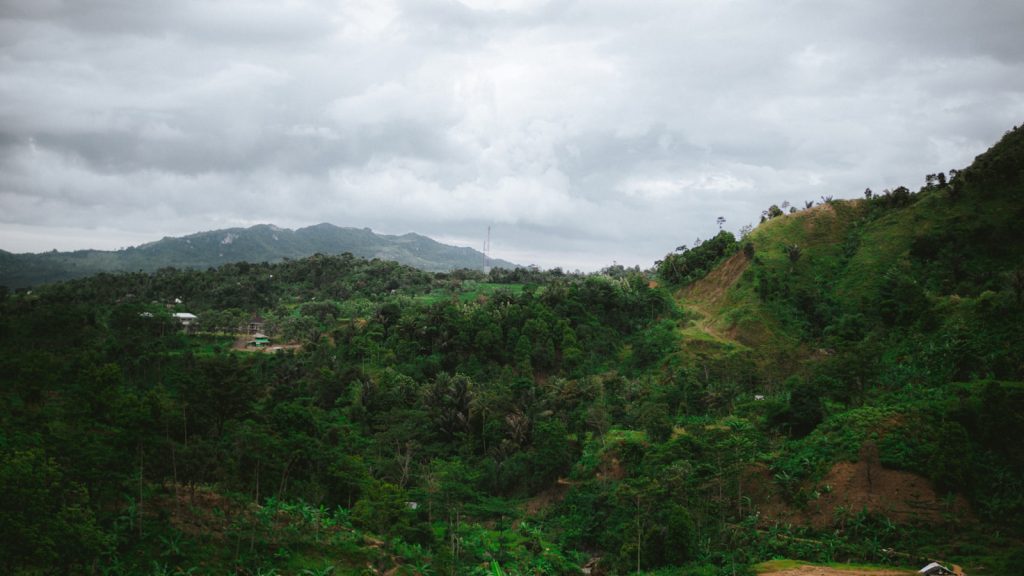
Where Nggorang Bowosie sits, and what it does for Labuan Bajo
The Nggorang Bowosie forest covers the hills that rise immediately behind Labuan Bajo town in Kecamatan Komodo, Kabupaten Manggarai Barat, East Nusa Tenggara. Functionally, it has long served as the town’s ecological buffer: a green belt that moderates runoff on steep terrain and contributes to water catchment for a town with chronic supply problems. Labuan Bajo’s main named PDAM source is the Wae Mese spring, and intermittent piped water and trucked deliveries are part of daily life there — context we cover in more depth in our water-scarcity explainer.
In official promotion, the area handed to the tourism authority is usually described as former production forest. The name Parapuar itself is Manggarai — “para” (door, gate) and “puar” (forest) — a detail BPOLBF’s own materials highlight. The two framings are not contradictory, but they emphasise different things: one stresses that the land was already classified for economic use, the other that it is, in the plain sense of the word, forest above a water-stressed town.
How a state forest became a tourism zone
Perpres 32/2018: the designation
Perpres 32/2018, signed on 5 April 2018, created BPOLBF (Badan Pelaksana Otorita Labuan Bajo Flores) and gave it two kinds of authority: a coordinating role across eleven kabupaten in Flores, and direct authoritative rights over a core area of roughly 400 hectares inside the Bowosie forest. That 400-hectare figure is used consistently in government promotion, though no cadastral or regulatory document publicly confirms it to the hectare; we treat it as a planning figure. Our Perpres 32/2018 explainer covers the decree itself.
The missing forest-release decree
For state forest land to become developable, it normally passes through a forest-area release processed by the environment and forestry ministry (KLHK), after which the land agency (ATR/BPN) can issue land rights. Here the public record has a genuine hole: the specific KLHK release decree (SK) number and date for Bowosie have not been identified in accessible media or NGO coverage. We state that gap rather than paper over it. It matters because the SK is the document that would show precisely which hectares were released, when, and under what conditions — the kind of primary record that would normally anchor any due-diligence file.
The HPL certificate, September 2023
The land-rights milestone that did happen publicly came in September 2023. An HPL (Hak Pengelolaan, a state land-management right) certificate covering approximately 129.6 hectares — Zone 1 of the planned area — was issued on 12 September 2023 and handed to BPOLBF at Parapuar on 15 September 2023 by Deputy Minister of ATR/BPN Raja Juli Antoni. Officials described the land as “clean and clear.” English-language reports sometimes render the figure as “129,609 hectares,” which is a number-format error: the Indonesian “129,609 ha” means 129.609 hectares. How HPL works for investors is a separate subject, covered in our HPL land-rights guide.
The four kampung and what they claim
The community side of this history centres on four kampung: Racang Buka, Kaper, Lancang and Nggorang. Residents of these settlements claim customary connection to, and long-term occupation and farming of, land inside the Bowosie forest. The cultivation claims as documented run from at least the 1990s, with some residents asserting use going back to the 1960s and 1970s.
An honest reading requires saying what kind of evidence this is. These are resident interview accounts gathered by journalists and NGO researchers — not cadastral records, registered titles, or court findings. That does not make them false; customary and informal cultivation in Indonesian state forests frequently leaves no paper trail, which is precisely why such claims are hard to adjudicate. But it does mean the claims have a different evidentiary character from the state’s certificates, and readers should hold both facts in mind at once: the state holds the formal documents, and the formal documents are not the whole history of who used this land.
A coalition of the four kampung organised to resist the project as planning hardened into land clearing. Their core grievances, as reported, were that the designation proceeded without their consent, that cultivated plots and livelihood areas fell inside the zone, and that no recognition or compensation framework was put in front of them before machinery arrived.
Blockades and demonstrations, 2022–2023
The dispute became physical in 2022. Residents blocked land clearing and heavy machinery inside the Parapuar area — direct, on-the-ground obstruction, not just statements. Demonstrations followed in Labuan Bajo through 2022 and 2023, and survey teams working the site were confronted. Civil-society reporting from the period describes “aksi demonstrasi dan pengadangan” (demonstrations and blockades) running in parallel with the administrative push toward HPL certification.
The sequence is worth registering plainly: the blockades and protests preceded the HPL certificate of September 2023, the Parapuar Park groundbreaking of 8 August 2024, and the investor announcements of 2025. The state process did not pause for the dispute; it moved through it.
Who has documented the dispute
Four names recur in the record, and anyone researching Bowosie seriously should know them.
Sunspirit for Justice and Peace, a Labuan Bajo-based NGO, has done field research and community organising around Bowosie and is the closest thing to a continuous local monitor of the dispute. Floresa.co, the Flores-focused news outlet, has published investigations on the forest and the project from roughly 2019 through 2024 and remains the deepest journalistic archive on the subject. WALHI NTT, the provincial chapter of Indonesia’s largest environmental organisation, has issued statements opposing the forest conversion on ecological grounds. AMAN Nusa Bunga, the regional chapter of the Indigenous Peoples Alliance of the Archipelago, has framed the claims in masyarakat adat (customary community) terms.
NGOs have also referenced letters and petitions sent to the President and to Komnas HAM, Indonesia’s national human-rights commission. We flag these carefully: no public docket numbers for those submissions have been identified, and we found no documented formal Komnas HAM inquiry specific to Bowosie. The letters are reported to exist; their official processing status is UNVERIFIED.
If you are researching Parapuar and want help locating primary sources on the Bowosie record, or want this history weighed against a due-diligence checklist, send us a question through our contact page — we read everything and answer plainly.
Two accounts of the same land
The table below sets the official account and the community account side by side. Neither column is editorialised; each reflects what that side has actually said or done on the record.
| Question | Official account (BPOLBF / government) | Community account (four kampung and advocates) |
|---|---|---|
| What was Bowosie before Parapuar? | State forest, described in promotion as former production forest already classified for economic use | A living landscape cultivated by surrounding kampung, and the town’s ecological buffer and catchment |
| Who held rights to the land? | The state; HPL Zone 1 (≈129.6 ha) certified to BPOLBF on 12 September 2023, described as “clean and clear” | Residents claim customary occupation and farming from at least the 1990s, some accounts to the 1960s–70s (resident testimony, not cadastral records) |
| Was the process consultative? | Official materials describe socialisation and buffer-village programmes | Kampung coalition says designation and clearing proceeded without consent; blockades in 2022 were the response |
| What about the environment? | Pledge that only ~20% of the zone is built and ~80% stays green/forest | Critics argue fragmentation, roads, and utilities degrade catchment function even where trees formally remain |
| Where do claims stand in 2026? | No published settlement framework; development and investor promotion continue | Claims maintained; no compensation scheme or formal adat recognition documented |
Water: the Wae Mese question
Of all the environmental concerns raised, water is the most concrete. Labuan Bajo already lives with scarcity — intermittent PDAM supply, water trucks, hotels competing with households. The Wae Mese spring is the main named source for the town’s piped system, and Bowosie’s hills are part of the catchment geography that recharge depends on.
Critics’ argument runs in a straight line: clearing and hard surfaces on the hills above a water-stressed town reduce infiltration, increase runoff, and raise flood and landslide exposure on slopes that drain directly toward settlements. The official response leans on the 20/80 pledge and on the framing that construction is confined to designated sub-areas. What does not exist in the public record, on either side, is a published hydrological study quantifying Parapuar’s effect on the Wae Mese catchment. Investors weighing utility-dependent projects on the hill should note that absence — and that the town’s water constraint binds their own future operations too.
The 20/80 pledge — and the fragmentation critique
BPOLBF’s central environmental commitment is that only about 20% of the area will be built on, with roughly 80% kept green or forested. On the HPL parcel, official material puts planned utilisation at around 20% of the ≈129.6 hectares — about 26 hectares of buildable footprint.
The critique, made publicly by environmental advocates, is that percentage pledges measure the wrong thing. A forest cut by roads, utility corridors and clustered development is ecologically fragmented even when most of its trees stand; edge effects, altered drainage and human activity change how a catchment behaves well beyond the built footprint. There is also a simpler scepticism: the pledge is a policy statement, not an instrument with published enforcement machinery, monitoring data, or penalties attached.
We present both because both are real. The pledge is genuine and consistently repeated in official material; the critique is genuine and unanswered by published evidence. A reader can hold the view that 20/80 is better than most development models and still note that no independent monitoring of it exists.
Where things stand in 2026
The fairest single description of the Bowosie dispute today is: ongoing and structurally unresolved. Through 2024, 2025 and into 2026, we found no publicly documented settlement covering the kampung claims, no published compensation scheme, and no formal recognition of adat claims over the zone. In the same period, the project advanced on every other front — HPL certification (2023), the Parapuar Park groundbreaking (August 2024), and investor promotion through 2025, including the reported Dusit and Eiger commitments tracked on our investor tracker.
“Unresolved” does not mean the project is illegal, halted, or certain to face escalation; it means the underlying claims were never adjudicated or settled in any public process, and the people who made them have not withdrawn them. Disputes in that condition can stay quiet for years. They can also resurface — through litigation, protest, political change, or international attention — at times no one schedules.
Bowosie at a glance
- Forest name
- Nggorang Bowosie, Kecamatan Komodo, Kabupaten Manggarai Barat, NTT
- Designating instrument
- Perpres 32/2018 (signed 5 April 2018), creating BPOLBF with authority over ~400 ha (planning figure)
- KLHK forest-release decree
- Number and date not publicly identified — a standing documentation gap
- HPL Zone 1
- ≈129.6 ha; certificate issued 12 September 2023, handed to BPOLBF 15 September 2023
- Kampung with claims
- Racang Buka, Kaper, Lancang, Nggorang
- Claimed cultivation period
- From at least the 1990s; some accounts to the 1960s–70s (resident testimony, not cadastral records)
- Physical resistance
- Blockades of land clearing in 2022; demonstrations in Labuan Bajo 2022–2023
- Documented advocates
- Sunspirit for Justice and Peace; Floresa.co; WALHI NTT; AMAN Nusa Bunga
- Letters to President / Komnas HAM
- Referenced by NGOs; no public docket numbers; UNVERIFIED processing status
- Settlement status (mid-2026)
- No publicly documented settlement, compensation scheme, or formal adat recognition
- Key water source nearby
- Wae Mese spring, Labuan Bajo’s main named PDAM source
What this history means if you are evaluating Parapuar
We are an information site, not advisers, and nothing here is investment or legal advice. But the due-diligence logic is not complicated. The state’s paper at Parapuar is strong on its face — an HPL certificate described as clean and clear. The unsettled layer sits beneath the paper: claims that were never resolved, communities that publicly resisted, and a documentation gap at the forest-release step. Serious investors typically ask for the KLHK release documentation, ask BPOLBF directly how kampung claims affecting their specific lot were handled, and price in the reputational dimension — a branded hotel on contested forest land is a different ESG proposition from one on uncontested ground. The broader risk picture, beyond land history, is in our risks and due-diligence file; Indonesian-language readers can also see our ringkasan konflik lahan Bowosie.
Frequently asked questions
What is the Bowosie forest in Labuan Bajo?
Nggorang Bowosie is the state forest on the hills directly above Labuan Bajo town in West Manggarai, Flores. It functions as the town’s ecological buffer and part of its water catchment, and roughly 400 hectares of it were designated for the Parapuar tourism zone under Perpres 32/2018, with ≈129.6 hectares certified to BPOLBF as HPL in September 2023.
Who claims customary rights over Bowosie?
Residents of four kampung — Racang Buka, Kaper, Lancang and Nggorang — claim long-term occupation and farming inside the forest, with cultivation accounts running from at least the 1990s and some reaching back to the 1960s–70s. These claims rest on resident testimony documented by journalists and NGOs rather than on cadastral records, and they have not been formally adjudicated.
Has the Bowosie land conflict been resolved?
No, not in any publicly documented way. As of mid-2026 there is no published settlement, compensation scheme, or formal recognition of adat claims, while HPL certification (2023), groundbreaking (2024) and investor promotion (2025) went ahead. The most accurate description is ongoing and structurally unresolved.
What happened during the 2022 protests?
In 2022, residents physically blocked land clearing and heavy machinery inside the Parapuar area, and demonstrations were held in Labuan Bajo through 2022 and 2023. Survey teams were also confronted on site. The administrative process continued through this period, culminating in the HPL certificate handover of 15 September 2023.
Does the dispute make investing in Parapuar illegal?
No. BPOLBF holds a state-issued HPL certificate over Zone 1, and cooperation with investors proceeds on that legal basis. The dispute is a matter of unresolved community claims, documentation gaps and reputational exposure rather than a current legal bar — which is exactly why it belongs in due diligence rather than being ignored. We are not advisers; verify any lot-specific question directly with BPOLBF and qualified counsel.
Bowosie is the part of the Parapuar story most coverage leaves out, and the part most worth understanding before anything else. If you want help framing the right questions to put to BPOLBF or to independent counsel about land history on a specific lot, ask us through the contact page and we will point you to the primary sources we know. If you use our free help and proceed with a professional we introduce, that professional may pay us a referral fee at no extra cost to you.